|
Analytics
Latest development and prospects of the «Khazar Project»
18.02.2010, Education Irina Arzhantseva, Vladimir Petrukhin, Valery Flyorov
The studies undertaken within the framework of the Khazar Project in the southern part of the Eastern Europe, beginning in 2000, were triggered at the time of the rebirth of the Jewish education system in the new Russia.
There appeared a necessity to deal with the problems related to the prehistory of the Jewish Diaspora in Russia including the Khazar one. New academic courses and archaeology fieldwork opportunities for students majoring in history were required. In Russia, the rising tide of interest in these issues has also contributed to the growing attention of the international academic community.
In the spring of 1999, the First International Colloquium specifically devoted to Khazars was convened in Jerusalem, Israel and then, in 2002, the Second International Khazar Colloquium was held in Moscow, Russia. Their papers were published in Moscow in 2005.
Students from the Jewish University in Moscow began fieldwork with the archaeological expedition directed by Dr. I. A. Arzhantseva at the site of the Alan fortress “Mountain Echo” near Kislovodsk in Russia. In accordance with the syllabus, the study of the Khazar monuments as such was deemed necessary. In this regard, archaeologists’ attention has long been drawn to the ancient settlement site of Samosdelka on an island in the Volga estuary, the
very geographic location of which had provoked the search for Itil, the capital of the Khazars. Thus, the Khazar Project was taking shape, and those involved in it were naturally concerned about the fate of the Khazar monuments which were just falling apart in front of our eyes. The history of the establishment of the Khazar cities’ network became the major issue for the Khazar Project researchers.
Another promising archaeological site was the eponymous for the Khazar archaeology (Saltov-Mayaki culture) fortress in the settlement of the Upper Saltov. In Kharkov, Dr. V. K. Mikheev from the Eastern-Ukrainian Affiliated Department of the International Solomon University has established the Center for Khazar Studies. A portion of the Khazar Project resources was allocated to the arrangement of summer students’ schools and their work in Saltov. However, the research of the deteriorating fortress itself was not continued. In 2003, rescue archaeological works led by Dr. V. S. Flyorov were started at the Don ancient settlement sites of the Khazar Khaganate, primarily at
the right bank Tsimlyansk ancient town site.
The funding of the Project was most generously provided by the Russian Jewish Congress (RJC) at the time when it was headed by Yevgeny Satanovsky, a businessman and the President of the Institute for Israeli and Middle-Eastern Studies in Moscow. Presently, Mr. Satanovsky continues to support the Project.2 Within the framework of the RJC’s academic programs, financing was naturally allocated to projects directly relating to Judaica and
the history of Jews in Russia. The researchers of the Khazar settlements were aware of the fact that there were virtually no scientific findings in the Khazar archaeology in this range of problems.
Concurrently with the archaeological studies, epigraphical ones were also started – at the famous cemetery of the cave town Chufut-Kale in the Crimea (A. M. Fedorchuk, International Center for Jewish Education and Field Studies).3 Karaites’ ethno-romantic legends carry the origin of the monument back to the Khazar time or even to classical antiquity. At this cemetery, one of the largest in the Jewish Diaspora, there are nearly 7,000 gravestones, about 3,400 of which are with epitaphs dating from the 14th to the 20th centuries. Its epigraphical description was completed in 2006. Currently, under the auspices of the Euro-Asian Jewish Congress (EAJC) an electronic catalogue of the necropolis has been virtually finished and its print edition is underway. The study of the late Roman settlement at the Vishesteblievskaya-11 site in the Taman region (S. V. Kashaev, Institute for the History of Material Culture) was to a great extent linked with the Khazar range of problems. The settlement is distinctive in that a score of gravestones with Hebrew symbols have been discovered over recent years on its territory, mostly found in reuse or excavated. Also, at the monument, geophysical mapping of several lots of the settlement have been carried out. The aim was to find the necropolis of the early centuries A.D. Indicators of the existence of
ancient necropolis are, alongside the undamaged gravestones, a lot of fragments of limestone with inscribed Hebrew symbols.
The pattern in which the gravestones are laid in the causeway of one of the dwellings provokes the researchers to suppose that the stones with Hebrew symbols had been used ritually. In one way or another, the concentration
of gravestones shows that there was a Roman necropolis nearby. One’s attention is drawn to the “experiments” with the Hebrew gravestones in Taman: one of them is mounted into the wall of a burial box. Also, gravestones
with “non-canonical” graphic themes were discovered: one of them, an accidental find in the vicinity of the ancient city of Kepi, has a picture of a “tree” topped with a menorah; another one, from the Vishesteblievskaya, has
only an inverted tree. The tree is a universal depictive motive also known in the Hebrew symbolics: lulav, a frond of the date palm tree used to be depicted next to a menorah. The tendency of transforming the menorah into a tree has long been known in the Hebrew graphic tradition proper – on the menorahs of the time of Rome.6 Due to the likely relation of the tree motive to the Turkic tradition, the studies in the Taman region aimed at shedding light on the
problem of the conversion of Khazars look promising.
The major efforts of the Khazar Project are directed to the study of the Khazar time settlements in the Northern Caucasia (Mountain Echo), in the Volga estuary (Samosdelka) and the Don region. Among them is the monument which belongs to the classic of Khazar archaeology – the Right-bank Tsimlyansk ancient town site. Although it became generally known in the mid-18th century, it was only in the 1920s that it actually entered the area of interest of the Khazar studies when M. I. Artamonov, as a member of Northern Caucasian expedition of the State Academy for the History of Material Culture, studied it and assigned to white-stone Saltov-Mayaki culture. Thereafter, the scholar repeatedly wrote about the ancient town, including his main work The History of the Khazars,7 in which he attributes the destruction of the white-stone fortress to the discord that occurred among the Khazars.
The first major excavations at the site were carried out in 1939 by I. I. Lyapushkin. It was he who found that the main type of dwellings in the fortress were yurt-shaped ones. His stratigraphic observations are of the utmost interest. In 1958 through 1959, the work at the monument was continued by Dr. S. A. Pletnyova. The result of the research was the discovery of a new series of yurt-shaped dwellings, of elements of the structure of the main gateway and of a corner tower.
In 1987 through 1988, and in 1990, a Soviet-Bulgarian expedition led by Dr. V. S. Flyorov, carried out major excavations of the fortress’s southern corner. For the first time at the site, there was discovered a big well-preserved
portion of foundations of the vallum and two towers, as well as of a gate building consisting of two dwellings. The fortress that stood at what is now the archaeological site was built at the very end of the 8th – beginning of the 9th century. It was made of well cut white limestone masonry blocks. It was triangular in plan 110 × 130 × 135 meters in order to fit the terrain. The thickness of the walls was up to 4.25 meters and their height could have reached 8 meters. There were eight rectangular towers in the wall. The main gate was of an elaborate design with an additional inside wall preventing straight line passage. The interior space was divided by narrower walls into three sections one of which, the southern one, had an exit, through the southern tower of the eastern wall. As late as the 18th century, the fortress walls and towers were still 2 to 3 meters high, when they were disassembled with the material being used for construction in the Don Voisko center town of Cherkassk. Despite these destructions, the Right-bank ancient town site has very well survived as an archaeological monument (much better than the Sarkel site where only the footprints of the walls are left).
The Right-bank fortress bears the influence of the Byzantine fortification. It was possible that the Byzantine craftsmen had taken part in its construction. The fortification of the Right-bank fortress is so sophisticated that it has no equal among the white-stone fortresses in the Khazar Khaganate. In the two main interior sections of the fortress there are many well preserved foundation pits of dwellings, about fifty of which have been already studied by I. I. Lyapushkin, S. A. Pletnyova and V. S. Flyorov. Many archaeological finds were recovered from the dwellings and the occupation layer. The work was interrupted by the 1998 Russian financial crisis. It became possible to resume operations only in 2003 when the Right-bank Tsimlyansk ancient town site was included in the Khazar Project: thus, the new stage of studies was commenced.
The Khazar Project turned to the Right-bank ancient town site not only because of its outstanding scientific significance but perhaps, first and foremost, due to the prevailing conditions at the Tsimlyansk Reservoir which cannot be referred to but as an archaeological disaster.10 From the time the Reservoir was filled in 1951 it has been wearing away the coast with an accelerated speed. Measurements taken by the Expedition started in 2003 show that the brim of the coastal cliff in front of the ancient town site moves back 54 cm a year on the average, and in some places it is up to 90 cm. The last portion of the eastern vallum discovered in 2006, which is hanging over
the cliff, is being lost. Considering the modest dimensions of the monument, the retreatment of the coast line (its altitude over the reservoir surface is 43 meters) will bring about its total disappearance in the near decades. We
shouldn’t expect the state authorities represented by Ministries of Culture, Natural Resources, Water Resources, agencies in charge of the condition of artificial reservoirs and local monument protection agencies to assume responsibility for what is going on and start funding rescue archaeological works on an annual basis. Neither under the former Soviet legislation nor under the current legislation of the Russian Federation were or are such
measures provided.
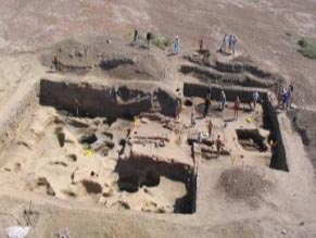
The Right-bank Tsimlyansk ancient town site is a monument of utmost scientific importance. It requires immediate measures to be taken for its preservation, first and foremost to turn it into an archaeological park. Then it is essential to begin designing the stabilization of the coast line in front of the site which should put a stop to the destruction of the monument. Another important monument studied within the framework of the project is the ancient settlement site of Samosdelka in the Astrakhan Oblast 40 kilometers off the city of Astrakhan. The monument is located in unique landscape conditions of the Volga estuary, the place where the emergence and lifehistories of archaeological monuments largely depended on the transgressions of the Caspian Sea. The archaeological research data do not typically reveal direct information about the paleoenvironment conditions at the time when the monument had actually existed. Such information can be gained only as a result of comprehensive interdisciplinary research. The excavations started in 2000 (led by E. D. Zilivinskaya, with the participation of archaeologists from Astrakhan D. V. Vasilyev and T. Yu. Grechkina) confirmed that the monument dates back to the Khazar time. The long-range objective of the comprehensive research is to reconstruct the life of the settlement, including the paleolandscape environment and the economic activity of the inhabitants. Therefore, alongside archaeological and geophysical studies, a group of soil scientists from the Institute of Geophysics of the Russian Academy of Sciences (M. A. Bronnikova, I. V. Turova and E. P. Zazovskaya) carried out paleosoil studies that provide a basis for paleolandscape reconstructions.
The chronology of the monument has been determined in outline. Settlements might have appeared there in the 9th century and existed continu ously until the 30s – 40s of the 14th century, and after that the territory was flooded. The occupation layers are overlain by a thick bed of water-rolled chippings of pottery, bones and bricks mixed with a lot of river shells, which is an indication of an extended period of the site flooding. This is why, it is ather difficult to determine the boundaries of the monument. Most likely, the ancient settlement ranged as a narrow one-kilometer-long strip along the Old Volga riverside. The total area of the monument, as we know it today, is about
2 km2; it is divided into three parts by the Volga channels.
The structure of the monument is complex. The main part of the settlement site is located on an island stretching along the old dry riverbed of the Volga river. The island is surrounded on all sides by dry courses. According to paleosoil studies, in the 9th through 12th centuries, these courses were filled with water. Presumably, the present-day riverbed was the eastern boundary of the ancient settlement, while the northern and the northwestern
boundaries went along Volozhka, the old dry Volga riverbed. At the “foreland” between the old and the existing riverbeds there is a rolling plain formed by the ancient settlement’s occupation layer bedding. On the aerial
photograph made from a helicopter, as well as on the topographic plan of the ancient settlement site, one can clearly see at the riverside section of the plain a triangular rise surrounded by “mounds”. The dimensions of the plain
(of the p robable citadel) are 360 × 300 × 220 meters. In comparison, the dimensions of the Khazar fortresses in the Don region are the following: the rectangular in plan Sarkel citadel was 186 × 126 meters; the triangular in
plan of the Right-bank Tsimlyansk ancient town citadel was 175 × 150 × 110 meters. It is on this plain that a substantial concentration of broken brick, pottery and other kind of finds occur. They might be the remains of the citadel,
but only further excavations can prove whether this assumption is true or wrong.
The geophysical study undertaken at the site in 2003-2004 (led by M. J. Kats from the research and development center “Geotechnology”) also yielded very interesting material (in particular, it revealed considerable magnetic
anomalies at places where a “mound” could have been). Following the magnetic-survey data interpretation, a map of the residual anomalies defining the distribution of broken brick over the surface was compiled. The frequency
of pottery distribution over the surface is governed by the probability laws and therefore can be used in defining the boundaries of the ancient settlement. Likewise, the frequency of the distribution of broken brick might
well be governed by the same laws, in which case studying the frequency of that distribution we will be able to define the most probable location of the former brick walls. Geophysical exploration with the use of a variety of methods and devices yielded the following preliminary results:
- The boundaries of the ancient settlement are defined south, southwest and west of the existing excavation.
- Three layers rich with pottery varying in their physical characteristics (different conductivities) were distinguished in the overall formation of the occupation layer. The lower layer could be associated with the early years of the monument.
- Within the limits of the monument, on a 100 × 100-meter lot there were sections defined where it was most likely to find remains of walls made of burnt brick.
Beginning in 2000, a team of the archaeological expedition carried out excavations on the insular section of the monument, at its highest location. The thickness of the occupation layer there is over 3 meters. Though the study
of the ancient settlement has been going on for only six years, we can already say much about what the town looked like and what were the occupations of its inhabitants.13 What is interesting is that two types of dwellings were defined on the monument: the rectangular and round in plan. The latter are possibly the remains of the yurt-shaped dwellings known to have existed in the Khazar time, which, most likely, testifies that the local population had ties with the nomadic tradition. Brick structures in the settlement site of Samosdelka mostly belong to the 11th – 13th centuries. However, it is noteworthy that all these structures are made of reused bricks taken from earlier structures, which is a good reason to believe that in the earlier period (the Khazar time?) brick was also used for building. The inhabitants of the Samosdelka settlement practiced husbandry, home and distant pastures cattle breeding and fishery. The settlement was a major center of artisan production. The Samosdelka pottery production gained momentum. Most of the forms of both earthenware ceramics and molded pottery are analogues to those of the 9th – 12th centuries Volga Bulgaria. Of special interest is the richly ornamented molded pottery made of roughly mixed batter, having strong resemblance to the 10th-century ceramics from “marshy settlements” discovered by the Khwarezm expedition at the lower reach of the Syr-Darya river. The settlements were inhabited by Turkomen-Oguz people who, on account of the drying up of the Syr-Darya riverbed in the 11th century, began migrating to the west ultimately reaching the lower course of the Volga.
As a result of the study of the ceramic finds, two main ethnic groups that inhabited the Samosdelka settlement in late Khazar and pre-Mongolian times were defined. They were Bulgarians and Oguzes. Still, the problem of sorting
out the Khazar antiquities is of a particular interest. The chronology of the Samosdelka settlement site will have to be adjusted. The main age-dating material of this monument is ceramics the typology of which has not yet been devised. Currently, the basis of age-dating is the ceramics imported mainly from Central Asia where the accuracy of its stratification is sufficiently good. Also, a series of radiocarbon dates has been acquired according to which the lower levels of the occupation layer are dating from the late 8th to the early 9th centuries.
Tentatively, the culture of the settlement cannot be classified as Saltov-Mayaki culture: it could have been left by the Turkomen or, maybe, the Khazars. Within the framework of the Khazar Project, the study of the Alan fortresses,
most notably, of the fortress “Mountain Echo” near Kislovodsk is underway (led by I. A. Arzhantseva). The region of the Caucasian Mineral Waters and the upper Kuban is demonstrative in terms of the study of stone fortresses. Here, in the territory of the upper Kuban river, Pyatigorye and today’s Balkaria, at the turn of the 6th and 7th centuries, a network of settlements-fortresses of the same type came into existence. In the Khazar time, the system of these Alan fortresses, dated to the 6th – 9th centuries, played an important role in the historicalcultural space of this strategic for the Northern Caucasia and the southern Russia region. Alans, who were allies and tributaries of the Khazars, created a network of these fortresses to have control over the trade and military routes that passed through that territory.15 Though these small stone fortresses were more than once described by researchers (A. A. Yessen, V. B. Kovalevskaya, G. E. Afanasyev, D. S. Korobov, S. N. Savenko), only few of them were studied, albeit not systematically and in small areas (V. B. Kovalevskaya, G. E. Afanasyev). The fortress “Mountain Echo” had been selected from the fortresses of the Kislovodsk Hollow as a benchmark archaeological site for a comprehensive study, including a package of geophysical and paleosoil studies alongside archaeological works. “Mountain Echo” is at a strategic location at the very beginning of the longest ravine in the Kislovodsk Hollow. The excavations revealed unusual housing density. As early as in 6th century, “Mountain Echo” was already a large fortress. The structures were made out of big blocks of gray limestone mined at the rocky bottom terrace of the same foreland, turning it into an unassailable fortress: on a vertical rocky monolithic base there stood 4 to 6-meter thick and 6 to 8-meter-high valla with flanking and gateway towers. Along the perimeter of the major part of the rocky remnant, there were supposedly about nine large towers from 7 × 8 to 8 × 8 meters in plan and probably no less than 5-meters-high. They were located at intervals of 25 to 40 meters and between them there were walls. A separate structure was a vallum with a system of towers and extensions blocking the plain at its southern part.
As a result of large-scale excavations (over 700 m2 of occupation layer were exposed), two construction periods were traced, which rejects the formerly proposed hypothesis to the effect that such fortresses were single-layered and that they ceased their existence at the end of the 8th – beginning of the 9th centuries due to the outflow of the population from that microregion. There is no consensus as yet on what was the reason for the outflow. However, it is already quite clear now that these fortresses, or at least the most significant of them, continued to exist up to early 10th century. The major layer at the “Mountain Echo” dates to the 6th – 8th centuries.
During that period the interior space was densely built up with premises functional areas which ranged from 8 –10 m2 to 20 m2 or were even larger. Bearing walls, peripheral walls and the connecting wall are built of large
blocks of limestone. It is two-faced masonry with backfill; the blocks are well finished and closely fitted to each other. The footing course was laid upon clay bedding. The presence of clay beddings and lean clay mortars shows that the structures were built to withstand regional seismic hazard. In living spaces, all along the walls remains of stone sleeping benches were found. Two types of fireplaces existed in living and household rooms: rectangular corner fireplaces made of limestone slabs with traces of fire, and round ones covered with puddle clay located in the middle of rooms. Up to 20 living structures were exposed at the lower construction layer
of the main excavation area (780 m2). With this number taken to represent the overall average, the total number of such structures at the site could reach 70 or 80. Taking into consideration the towers that were not only fortified
structures but also served as living quarters, there could have been up to 300 or 400 people living in the settlement at the same time. Soil and landscape studies in the precincts of the “Mountain Echo” site resulted in some new hypotheses concerning the evolution of landscapes (geological and soil studies had been carried out for a number of years by S. N. Sedov, M. A. Bronnikova and I. V. Turova, researchers from the Russian Institute of Geography). The natural environment of the studied region (the Kislovodsk Hollow) was always favorable for pasture cattle breeding and husbandry. The forming and functioning of ethnocultural groups over the last
two millennia within the region of the Caucasian Mineral Waters took place in the context of predominantly grassy plant associations, where forests grew only in river valleys. The environment there differs from that in the Western
Pre-Caucasian region (upper reaches of Kuban, Zelenchuk and Marukha rivers and farther westward up to the Black Sea) where in Late Holocene age a sharp change of climate occurred and the predominant steppe ecosystem gave way to forests. Therefore, within the region of the Caucasian Mineral Waters in general and in the Kislovodsk Hollow in particular, conditions for pasture cattle breeding were always favorable as distinct from those in the regions farther to the west. Possibly, it was the climate, favorable for the economy and stable, together with an advantageous location in a network of trade and military routes that attracted the Alans to that place in the 5th century (according to numerous burial grounds it was during that period that there was an inflow of population in the Kislovodsk Hollow). Considering spacious farmlands and their high production effectiveness, it may be concluded that in the 6th through 8th centuries the population of the Kislovodsk Hollow produced enough agricultural goods not only to meet their own requirements but also to pay that tribute to the Khazars, the reference to which is found in written sources.
Owing to the well coordinated work of archaeologists and geoscientists (geophysical studies at the site were undertaken in 2003-2005 by M. J. Kats, I. N. Modin, A. S. Sokolov and A. N. Pelevin from the research and development
center “Geotechnology”) in the stratigraphic sequences and on the sides of the excavation, above the main 6th – 8th-centuries layer there was revealed in up to 80-centimeter-thick “destruction” layer with obvious signs of a fire.
The fire happened at the end of the main period (supposedly at the end of 8th century A.D.) after which the fortress was in a state of neglect for some time. In the same period (8th century A.D.) the fortress was damaged in an
earthquake which is evidenced by the specific character of the displacement of the walls of the buildings and by irregular fractures in the solid ground going down from under the buildings’ walls. This surface activity was dated by the ceramics characteristic of the period. It could have been the reason why some of the settlements ceased their existence and there was an outflow of the population to safer places. However, it is unlikely that the region had been finally deserted. At the fortress “Mountain Echo” a later construction horizon was detected which bears witness to the repeated settlement of the fortress by, perhaps, descendants of the original population. Though life in the monument didn’t cease to exist, its intensity decreased. The later period dates to the 9th – 10th centuries according to the ceramic material of the Saltov type and late red-clay amphorae.
The repeated construction and settlement took place directly over the “destruction” layer after it had been leveled off for the construction. It was in the late period (9th – 10th centuries) that over the former structure ¹1 (in pit ¹3) a yurt-shaped dwelling on a rock foundation was built against the connecting wall, in a strategically key place. Since at the “Mountain Echo” site remains of only one yurt-shaped dwelling were found, it is unlikely that large-scale migration of Turkic tribes to the territory of Alans could have taken place during that period. Most likely, what we have is a material evidence of the fact that a representative of the Khazar Khaganate authorities had been in the fortress for a long time.
Surely, the fortresses as such could not classify as embattled cities (such as more recent Kyafar or Lower Arkhiz). However, the network of such fortresses assumed, to an extent, quite “city-like” functions: the organization of
joint defense of “key” regions (both in terms of geographical location and political importance) and control over trade and military routes. The system of small fortresses continued to exist in the Khazar Khaganate up to late 9th – early 10th centuries. The study of how this network of settlements worked reflecting the development of the Khaganate bodies of government is an important task of the Project. A separate problem is the quest of necropolises of fortresses and towns under study, most of which are yet to be discovered.
The tasks of the Project are becoming progressively comprehensive: to more deeply understand the obtained data, the project participants had to turn to experts in written sources (the orientalist T. M. Kalinina) and in laboratory
analysis of the material (the archaeologist S. A. Ruzanova), as part of the basic research program of the Russian Academy of Sciences titled “The Genesis and Interaction of Social, Cultural and Language Communities”. To attract creative youth to the Project, it was decided to organize in 2009 a summer archaeological school on Jewish studies at the Right-bank Tsimlyansk ancient town site.
Without a coordinated partnership between local authorities, museumworkers and university professors it will be impossible not only to prot ect the monuments but even to have them registered. So, interaction with the authorities should become a major contribution of the EAJC and the RJC to the cause of preserving the monuments of the Jewish history and culture.
|
|